


 LinkBack URL
 About LinkBacks


 Reply With Quote
|
|
Results 126 to 150 of 158
Thread: Some random scribblings
-
08-02-2009 09:57 AM #126
I used to do that with my pretty scarf and claim that I had rainbow pubes. Then I would attack-hump people.
So it's clearly not just guys and beer cans.
FIRST POST ON PAGE 6, I WIN CHRISTMAS!
-
08-02-2009 12:49 PM #127
-
08-03-2009 12:47 AM #128Same great taste! Achievements:


- Join Date
- Jan 2006
- LD Count
- Thousands.
- Gender

- Location
- East Tennessee
- Posts
- 308
- Likes
- 0
In your sad 25 post per page little world... Originally Posted by Anonymoose

Meanwhile, I've got it set for 10, so you're lost somewhere in the middle of page 13.
-
08-03-2009 03:37 AM #129Veteran of the DV Wars


- Join Date
- Mar 2007
- LD Count
- ~35
- Gender
- Location
- Houston, TX
- Posts
- 4,553
- Likes
- 94
To everything thus far that I have not yet replied to, I love it.
And I have a Nikon D40, man. It's half of what makes me my living, and it's a good camera. No built-in autofocus, so older lenses that rely on the camera's autofocus won't have autofocus. Maybe that's why you ruled it out? Still a great camera, though!
-
08-03-2009 04:43 AM #130
The D40 I used had auto focus. Guess it had a newer lens?
 And yes, it is a great camera. Tres magic.
-
08-03-2009 10:36 AM #131Same great taste! Achievements:
- Join Date
- Jan 2006
- LD Count
- Thousands.
- Gender
- Location
- East Tennessee
- Posts
- 308
- Likes
- 0
I'm starting the whole search over for the dSRL.
Before I destroyed my right shoulder, this was a great way to camp. The bonus was, I could carry moreiced beerstuff, and I wouldn't have to carry it on my back. Santeetlah Lake is in Western North Carolina, close to the Smokies. From a scanned photo.

.
-
08-03-2009 08:35 PM #132
Sweet baby Jesus on a flying kanagroo in space orbiting around MARS!!
I love kayaking and I've only had the chance of going twice in my life.
Over here in Vancouver we've got places that will take you on a 6 day kayaking/whale watching trip. We've got the biggest orca population in the world. AND GOD DAMN IT, I WILL GO ON THAT TRIP!
-
08-04-2009 04:07 AM #133Same great taste! Achievements:
- Join Date
- Jan 2006
- LD Count
- Thousands.
- Gender
- Location
- East Tennessee
- Posts
- 308
- Likes
- 0
I've gone on awhile here and a to a few folks in chat about how I trashed my right shoulder. It was the first day of Summer 2002, and I was headed out a ridge to a campsite maybe 6 miles away. I'd gotten maybe a half mile from where I parked, and I kicked a root sticking out of the trail. I stumbled, and should have just gone down, but I tried to recover. This resulted in a 10 yard running stumble that ended with me finally going down with the momentum of my stumbling run along with my weight and the weight of my pack all going into the one spot where I hit the ground first.. my right shoulder. I couldn't feel my right arm, but I still finished the two night trip. So I spent the next year trying to work around whatever was wrong. It's amazing how much you can lift in a gym when you've got cortisone lying to you that everything is OK. The MRI couldn't pin anything down since the damage was hidden deep inside the socket, so it was off to the orthopedic surgeon. He knocked me out and started poking around in my shoulder. Then he found this:
Time to start ripping the confetti out of there:
So here I am, minus this:Spoiler for Shredded:
That's a lot of cartilage, 20 mm (almost an inch) across, I liked it better when it was on the inside, this stuff doesn't grow back.Spoiler for I was using this.:
Ten days after this little operating room orgy, I was back on the trail.
.Last edited by Flavour of Night; 08-04-2009 at 07:18 AM.
-
08-04-2009 04:46 AM #134Same great taste! Achievements:
- Join Date
- Jan 2006
- LD Count
- Thousands.
- Gender
- Location
- East Tennessee
- Posts
- 308
- Likes
- 0
Remember the pika from a bunch of posts ago?
I was able to snap another one a few days later. This shot didn't turn out as crisp, but it's pretty neat because you can see how well camouflaged he is.

.
-
08-04-2009 09:47 AM #135Same great taste! Achievements:
- Join Date
- Jan 2006
- LD Count
- Thousands.
- Gender
- Location
- East Tennessee
- Posts
- 308
- Likes
- 0
Double Island (aka Campsite #78) on Fontana Lake in the Smokies. The naming of this island might seem odd since there is only one Island. A look at the topographical maps shows two islands. So what gives? Back in the 1940's, when Fontana Lake was formed by the damming of the Little Tennessee River at Fontana Dam, the full pool elevation was defined as 1710 feet. With Fontana Lake at 1710 feet, the island gets split in two by a narrow and shallow strip of water that covers the low saddle across the middle of the island. This is the condition shown on the topo map. In reality, Fontana Lake is never filled beyond about 1703 feet. At this level, the saddle across the middle of the island is above water... and thank goodness, since this is the only decent camping spot on the island.

And one heck of a nice camping spot it is. My trusty Walrus Rapeede tent is pitched. I've had this two man tent for better than a dozen years; it hasn't leaked a bit in all that time. Not even half a foot of wet snow can bring this thing down... steep sides for great snow-shedding, but it does give up some shoulder room in the trade-off.

.Last edited by Flavour of Night; 08-04-2009 at 09:58 AM.
-
08-05-2009 12:43 AM #136Same great taste! Achievements:
- Join Date
- Jan 2006
- LD Count
- Thousands.
- Gender
- Location
- East Tennessee
- Posts
- 308
- Likes
- 0
It's going to be a Canon 50D.
.
-
08-06-2009 07:34 AM #137Same great taste! Achievements:
- Join Date
- Jan 2006
- LD Count
- Thousands.
- Gender
- Location
- East Tennessee
- Posts
- 308
- Likes
- 0
Awhile back I posted a shot of the summit of Roan Mountain on the Tennessee/North Carolina Border. This is a shot from the parking area at Carvers Gap. Head in one direction, you end up on top of Roan Mountain. Head the other direction, you end up on top of Grassy Ridge Bald. This scan from a photo shows the mountainside in the direction of Grassy Ridge Bald.

.
-
08-07-2009 05:24 AM #138Same great taste! Achievements:
- Join Date
- Jan 2006
- LD Count
- Thousands.
- Gender
- Location
- East Tennessee
- Posts
- 308
- Likes
- 0
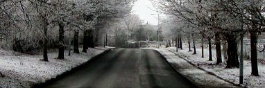
Kids should stay this age forever, or as least a bit longer than they do.

.
-
08-07-2009 07:52 AM #139Same great taste! Achievements:
- Join Date
- Jan 2006
- LD Count
- Thousands.
- Gender
- Location
- East Tennessee
- Posts
- 308
- Likes
- 0
Roan Mountain in the background, me showing off in the foreground. Not the sharpest shot, but I still like it.

.
-
08-09-2009 09:09 PM #140Member
- Join Date
- Aug 2009
- Gender

- Posts
- 323
- Likes
- 3
This picture is wonderful, and I loved what you showed us about cropping it. I also noted that there's a perfect heart just above the arch and to the right side of it... I remember seeing a whole collection once of natural hearts that someone photographed, and it was charming. I have one that forms from the dust in my driveway in a spot that's recessed just a tiny bit, I guess. I can sweep the driveway and it disappears, but it's back again soon! Originally Posted by Flavour of Night
-
08-09-2009 09:40 PM #141Same great taste! Achievements:
- Join Date
- Jan 2006
- LD Count
- Thousands.
- Gender
- Location
- East Tennessee
- Posts
- 308
- Likes
- 0
wow.. cool, never noticed the heart!
.
-
08-10-2009 05:47 PM #142Member
- Join Date
- Aug 2009
- Gender
- Posts
- 323
- Likes
- 3
LOL... it's probably being so loved that gives him all his confidence! So the heart is perfect there! Originally Posted by Flavour of Night
-
08-11-2009 07:54 AM #143that guy
- Join Date
- Oct 2008
- Gender
- Location
- candyland
- Posts
- 123
- Likes
- 0
wow you've got some beautiful photos there, also its good to see other BC ppl here.. you should come to van city and surrounding intereior area/ okanagan sometime, some shots to be had there, also much of it is camping friendly!
-
08-11-2009 04:51 PM #144Same great taste! Achievements:
- Join Date
- Jan 2006
- LD Count
- Thousands.
- Gender
- Location
- East Tennessee
- Posts
- 308
- Likes
- 0
Dreamnoob, I've never been to BC.. but I'm not adverse to the idea.
-
08-11-2009 08:01 PM #145that guy
- Join Date
- Oct 2008
- Gender
- Location
- candyland
- Posts
- 123
- Likes
- 0
yes theres some awesome sights here but you are a fair distance away, i should make a thread w/ my artwork and photography and drawings and such.. hmmm
-
08-12-2009 12:10 AM #146Same great taste! Achievements:
- Join Date
- Jan 2006
- LD Count
- Thousands.
- Gender
- Location
- East Tennessee
- Posts
- 308
- Likes
- 0
Bobs Towers (13,060') from way up close. (At least I'm pretty sure it is. This would make the peak tucked in behind Miriam Peak). I wasn't going to get too much closer without climbing equipment and rock skills I don't possess.

.Last edited by Flavour of Night; 08-12-2009 at 05:19 AM.
-
08-12-2009 05:44 AM #147Same great taste! Achievements:
- Join Date
- Jan 2006
- LD Count
- Thousands.
- Gender
- Location
- East Tennessee
- Posts
- 308
- Likes
- 0
I'm not sure what that last one is anymore. I was all over the top of Titcomb Basin, and I guess I have an excuse to go back to Wyoming now and figure it out.
From a much greater distance, I can say with certainty, that from left to right, you're looking at Woodrow Wilson Peak, The Sphinx, Bobs Towers, and Miriam Peak. Gannett Peak, Wyomings' highest, is hiding being them. The relatively low Dinwoody Pass (12,800')(far right) is the gateway to Gannett Peak from Titcomb Basin).

.Last edited by Flavour of Night; 08-12-2009 at 05:51 AM.
-
08-12-2009 11:38 PM #148
Take that picture, insert me riding on a bear (with antlers of course), and you have one of my most wanted LDs.
-
08-13-2009 02:38 AM #149Same great taste! Achievements:
- Join Date
- Jan 2006
- LD Count
- Thousands.
- Gender
- Location
- East Tennessee
- Posts
- 308
- Likes
- 0
If you want to ride a grizzly, be my guest. I'll be somewhere else. No telling if he might still be hungry after he finishes with you. Originally Posted by Anonymoose
-
08-13-2009 02:45 AM #150Same great taste! Achievements:
- Join Date
- Jan 2006
- LD Count
- Thousands.
- Gender
- Location
- East Tennessee
- Posts
- 308
- Likes
- 0
I figured out where that picture I thought was Bobs Towers was taken. It was taken a mile roughly WEST of Bobs Towers. So sue me.
I can't find a name for the pair of peaks, but they're located on a ridge due north of Knapsack Col at the top of Twins Glacier, about 1000 feet along the ridge rising up from the col at elevations of ~12,900 and 13,100'. I'm sure they have names or a common name between them.
You really needed to know all that, didn't you? I might bore the hell out of you, but the next time you're lost in the wilderness with no damned clue where you are or whether you should shit or wind your watch, you'll be wishing you listened better!
.


 Posting Permissions
- You may not post new threads
- You may not post replies
- You may not post attachments
- You may not edit your posts
Powered by vBulletin™
Copyright © 2025 vBulletin Solutions, Inc. All rights reserved.
Search Engine Friendly URLs by vBSEO
Copyright © 2025 vBulletin Solutions, Inc. All rights reserved.
Search Engine Friendly URLs by vBSEO
Bookmarks